
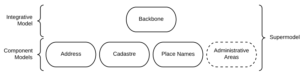
This 'Supermodel' is a set of data models used by Queensland Spatial Information to integrate data from formerly separate systems into an interoperable whole.
1. Metadata
IRI |
|
Title |
QSI Supermodel |
Description |
This is an overarching model - a Supermodel - used to integrate multiple, individual, models together for use within a particular scenario. |
Created |
2022-03-13 |
Modified |
2026-04-21 |
Issued |
0000-00-00 |
Creator |
KurrawongAI, for QSI |
Publisher |
|
License |
|
Code Repository |
2. Introduction
Multiple fundamental spatial datasets in Queensland have had system upgrades and been remodelled to modernise their tools and content structure and to align them better with one another. For example, the Address and Geographical Names data have been moved from old, separate, relational databases into a single modern graph database and cadastral information has had its underlying spatial technology upgraded. The Address, Geographical (Place) Names and Cadastral data models have been updated to either directly use, or to make public correspondences to, the "Background Models" in the overview diagram above.
For all datasets in all systems, their codelists, lookup values and feature types have been updated into stand-alone controlled vocabularies, many of which are standardised with other ANZ jurisdictions and published by ICSM.
By using/corresponding to Background Models and using standard terms from Vocabularies, the "Component Models" for each major QSI dataset share common structural patterns and values such that they can be cross-queried and used together in many ways. For example, you can query the combined system for an Address and get any Geographical Names that are part of it and their spatial extents, as well as the Property grouping of cadastral parcels it is an address for and their spatial extents.
In addition to component system upgrades and model upgrades, a number of new web services and data platforms have also been implemented by QSI to make using these now harmonised models together much easier at a technical level: single access points, etc.
2.1. Modelling System
All the models in this Supermodel set are implemented using the Web Ontology Language OWL. OWL is a very widely used, standardised, formal modelling language. Unlike UML models, OWL models natively have machine-readable forms allowing data made according to them to be automatically validated and processed into databases.
The Supermodel’s constituent models are related to one another using The Profiles Vocabulary PROF which provides properties to indicate when and how one model reuses - "profiles" - another. PROF also links models to validators created to test data claiming conformance to them.

2.2. Integrative Models
An Integrative Model is a main model that all the Component Models within a Supermodel context implement and extend for their specialised purposes. Supermodels always have one or mode of these.
In this Supermodel, the two Integrative Models are:
-
GeoSPARQL - an international Semantic Web model standard for spatial data
-
Compound Naming Model - an Australian model for sophisticated object naming
-
schema.org - a general-purpose Semantic Web model
GeoSPARQL is used for the fundamental representation of spatial objects, for example in the Cadastre Model, a Parcel is a GeoSPARQL spatial Feature, as is an Addressable Object in the Address Model.

The Compound Naming Model is used to represent names for things that are made of many parts, including other names. The Address Model’s main class of Address is a specialised form of the Compound Naming Model’s Compound Name, as is the Geographical Naming Model's Geographical Name.
schema.org is used to provide common relationships between things such as has part - something being part of another thing.
Since all the Component Models reuse GeoSPARQL’s Feature, Compound Naming’s Compound Name and schema.org relations, the Component Models' specialised information is known to be patterned according to these models and thus certain assumptions about them can be made before even looking in to their specifics. For example, we can assume, correctly, that all spatial objects in all Component Models are linked to geometry representations of them via a has geometry relation (or specialised version thereof) and that all geometries are available in Well-Known Text Well-Known Text form, given that i a requirement for GeoSPARQL Geometry objects.
The following figure provides an overview of the main elements of the Integrative Models in this Supermodel.

EXAMPLE: Yundah
Here is an example of a real Queensland address, 72 Yundah St, Shorncliffe, using Address, Cadastre & Geographical Names data, presented according to the elements in the Integrative Model overview figure, above.

A complete Address has much more information than this, such as Geocodes and Lifecycle stages, but this example shows the Address / Parcel main link between the Address Model and Cadastre Model.
2.3. Definitions
Here is a list of terms and acronyms used in this document.
- Background Model
-
A role within a Supermodel for low level or generic models that some, but not necessarily all, of the Component Models and the Integrative Model reuse and extend.
- Component Model
-
A role within a Supermodel for the models of individual datasets within the set aiming for interoperability. Component Models must reuse and extend the Integrative Model.
- Compound Name
-
The class of objects for "a literal value, or objects that can be interpreted as literal values, that describe or name a Feature", according to the Compound Naming Model
- Feature
-
The class of object for "Anything spatial (being or having a shape, position or an extent)", according to GeoSPARQL
- Geometry
-
The class of object for "A coherent set of direct positions in space", according to GeoSPARQL
- Integrative Model
-
A role within a Supermodel for models reused and extended by Component Models. Use of these models ensures general modelling patterns are present in all Component Models.
- IRI
-
Internationalized Resource Identifiers (IRIs) are Internet protocol standard identifiers used to identify, and often to link to representations of, resources. IRIs add internationalisation (use of different character sets to) Uniform Resource Identifiers (URIs) which are a superset of Uniform Resource Locators (URLs). Where URLs - web addresses - must link to resources, URIs often do but need not. [ref]
- profile
-
"A specification that constrains, extends, combines, or provides guidance or explanation about the usage of other specifications" according to The Profiles Vocabulary.
- Supermodel
-
A set of integrated data models used with defined roles used to make multiple datasets interoperable.
- Unified Modelling Language, UML
-
A general-purpose visual modeling language that is intended to provide a standard way to visualize the design of a system. [ref]
- Vocabulary
-
A controlled set of defined terms. Within Supermodel contexts, all vocabularies reuse and extend the SKOS vocabulary model.
- Web Ontology Language, OWL
-
A widely used international standard modelling language that allows for machine-readability of models.
- Well-Known Text
-
A text markup language for representing vector geometry objects. WKT was defined in ISO19125-1 and extended by GeoSPARQL to allow for Spatial Reference Systems.
2.4. Doc Structure
The structure of this document and the roles of each part are as follows:
-
Metadata - Metadata about this document
-
Introduction - An introduction to the Supermodel concept and this particular Supermodel
-
Models - The specific models within this Supermodel
-
Annex A: PID Rules - Rules for the Persistent Identifiers (PIDs) to be used by data wishing to conform to this Supermodel
-
Annex B: Validation - How to validate data wishing to conform to this Supermodel
-
References - All the important reference standards and models for this
3. Models
3.1. Supermodel
This Supermodel is the total set models listed here.
3.1.1. Human-readable Form
This document contains the normative, human-readable description of the Supermodel.
The Supermodel is the total set of models listed below and is also conceived of as a profile of the total set.
The models within this Supermodel and the roles they play are listed in the table below.
| Name | Description | Role | PID |
|---|---|---|---|
Address Model |
… |
||
Geographical Names Model |
… |
||
Road Names Model |
… |
||
Cadastral Model |
… |
||
Cadastral Survey Data Model |
… |
3.1.2. Machine-readable Form
The machine-readable form of this Supermodel is an OWL model, formulated according to the Profiles Vocabulary and is online at:
For technical use, the machine-readable versions of the Backbone Model and the Component Models can be combined and used as the total Supermodel.
3.2. Backbone Model
The Backbone Model for this Queensland Spatial Information scenario overviewed in Figure 3. The elements of the Backbone Model are described next and the formal characterisation of the model in OWL is given in the machein-readable file backbone.ttl.
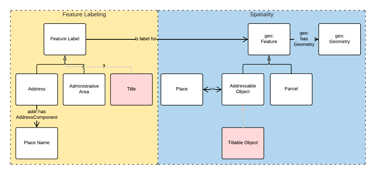
Figure 2 indicates two main conceptual domains (the yellow and blue) centered on Feature Labels (defined here) and geo:Feature s which are "Anything spatial (being or having a shape, position or an extent)" [GeoSPARQL]. Feature Labels are any form of identifying information assigned to a Feature [xxx].
The class hierharchy expressed in this Backbone Model (with sub class of arrows) indicates that:
-
Address,AdministrativeAreaand perhapsTitle`are all specialised forms ofFeatureLabel -
GeographicalNameis a form ofAddress(a very simple one!) -
Geographical Objectsare a specialised form ofAddressableObjectandAddressableObjectandParcel, and others, are speciali types ofgeo:Feature
The various Component Models (next) use these classes of object and imlplement many more specilised forms of them.
3.2.1. Classes
This Backbone Model only defines one class of object not already defined in the various Component models: FeatureLabel.
Feature Label
| Property | Value |
|---|---|
IRI |
|
Preferred Label |
Feature Label |
Definition |
An annotation applied to a |
Is Defined By |
|
Provenance |
Derived from [ISO19160-1]'s |
Expected Properties |
|
Example |
|
3.2.2. Properties
This Backbone Model only defines one property not already defined in the various Component models: isLabelFor.
is label for
| Property | Value |
|---|---|
IRI |
|
Preferred Label |
is label for |
Definition |
Indicates an an object that a |
Is Defined By |
|
Sub property of |
|
Domain |
|
Range |
|
Example |
see the example for Feature Label |
3.3. Component Models
3.3.1. ANZ National Address Model
The Address Model is a model that has been defined externally to this Supermodel.
It is available online at:
3.3.2. Geographical Names Model
The Geographical Names Model is a model that has been defined externally to this Supermodel.
It is available online at:
3.3.3. Roads Model
The Roads Model is a model that has been defined externally to this Supermodel.
It is available online at:
Annex A: PID Rules
This section provide the policy for the creation of Persistent Identifiers (PIDs) for objects within the scope of this Supermodel.
Type
PIDs within this Supermodel are IRIs which means they are typically represented like an Internet web address:
{SCHEME}://{AUTHORITY}/{PATH}
e.g. - the PID for this Supermodel:
https://linked.data.gov.au/def/qsi-supermodel
where the SCHEME is the HTTPS protocol, the AUTHORITY is linked.data.gov.au and the PATH is def/qsi-supermodel.
IRIs in this form should be quoted in full wherever possible, i.e. within datasets, exchange data and documents.
This IRI for this Supermodel does indeed resolve as a web address, to this document:
Authority
The authority for all identifiers used in this Supermodel is linked.data.gov.au which is the Internet domain name allocated to the Australian Government Linked Data Working Group (AGLDWG) expressly for the purpose of creating IRI PIDs for Australian government.
PIDs using linked.data.gov.au must be registered with the AGLDWG.
Non-IRI Representation
In Concept
Where an object cannot be identified with an IRI - perhaps the underlying technical system cannot store full web addresses - it may have an IRI substitute use which must consist of 2 data fields:
-
Object Identifier
-
System Identifier
The Object Identifier part can be anything used to uniquely identify the object within the context of the system identified by the System Identifier, for example an auto-incrementing number, a structured number, a string or a UUID.
|
Note
|
Since Object Identifiers are managed by individual systems, implementers of those systems may choose to indicate, or not, object classes within them, as long as all Object Identifiers managed by that system are unique within its context. For example, |
The System Identifier is the unique identifier for the system generating the Object Identifiers. It must be recorded in the table of Known Systems, below.
For each system identified in the Known Systems table below, a System PID Namespace is allocated. To assemble the IRI PID, the following logic is used:
IRI PID :== System PID Namespace / "dataset" / Object Identifier
For the Queensland Addressing & Location Information (QALI) system, the System Identifier is qali and the System PID Namespace is https://linked.data.gov.au/dataset/qld-addr, thus, for the Address with Object Identifier address/605bf8e7-315a-562b-af4c-16a870732daf, a class marker of "address" and a UUID, the complete IRI PID is:
In RDF data
Where a PID is represented in non IRI form and this must be stored in the RDF format, for example for exchange according to the Address Model, the Object Identifier must be represented as a literal with a custom datatype of the System Identifier and indicated with the schema:identifier if in an ontology or a dataset or skos:notation if in a vocabulary. For the address in the example above, this would look like the following:
<...>
    a addr:Address ;
    schema:identifier "address/605bf8e7-315a-562b-af4c-16a870732daf"^^<https://linked.data.gov.au/dataset/qld-addr> ;
.
Kinds
The following kinds of PID are to be allocated to data objects in this Supermodel:
-
high-level definitional object
-
the Supermodel itself
-
whole models and vocabularies within the Supermodel
-
-
low-level definitional object
-
Classes, Concepts, Predicates & Datatypes defined within models and vocabularies
-
-
high-level data object
-
whole datasets of content created in accordance with this Supermodel
-
-
low-level data object
-
objects within datasets
-
Definitional PIDs
Models and vocabularies within this Supermodel, and the Supermodel itself, are assigned high-level definitional object PIDs as per the table below and allocate low-level definitional object PIDs within their namespaces.
| ID | Name | PID Namespace |
|---|---|---|
|
The QSI Supermodel |
|
|
Address Model |
|
|
Cadastral Model |
|
|
Cadastral Survey Data Model |
|
|
Geographical Model |
|
|
Road Names Model |
|
ICSM Address Vocabularies |
||
|
Address Classes |
|
|
Address Types |
|
|
Address Status Types |
|
|
Address Level Types |
|
|
Geocode Types |
|
Known Systems
The following are all the known systems creating identifiers for data within the scope of this Supermodel as well as known class markers used by them. The systems use high-level data object PIDs for their major datasets and low-level data object PIDs for each element of those datasets.
- NOTE
-
It is not necessary for systems to use unique PID Namespaces as long as unique Object Identifier creation can be guaranteed across all systems sharing a PID Namespace. Systems may also be allocated more than one PID Namespace if, for example, they are responsible for more than one distinct conceptual dataset.
| ID | Name | PID Namespace | Class Markers |
|---|---|---|---|
|
Queensland Addressing & Location Information (QALI) |
|
|
|
Spatial Information Repository (SIR) |
|
Unresolved Questions
-
where do Road, not Road Name, IDs come from?
-
where do Property (Parcel Aggregate) IDs come from?
References
- [Address Model]
-
Intergovernmental Committee on Surveying & Mapping. Address Model, 2024. Semantic Web model. https://linked.data.gov.au/def/addr
- [Cadastre Model]
-
Intergovernmental Committee on Surveying & Mapping. Cadastre Model, 2024. Proposed Semantic Web model. https://linked.data.gov.au/def/cad
- [Compound Naming Model]
-
Australian Government Linked Data Working Group, Compound Naming Model 2023. Semantic Web model. https://linked.data.gov.au/def/cn
- [GeoSPARQL]
-
Open Geospatial Consortium, OGC GeoSPARQL - A Geographic Query Language for RDF Data, Version 1.1, OGC® Implementation Specification (2024). http://www.opengis.net/doc/IS/geosparql/1.1
[Cadastre Model] Intergovernmental Committee on Surveying & Mapping. Geographical Names Model, 2024. Proposed Semantic Web model. https://linked.data.gov.au/def/gn
- [ISO19125-1]
-
International Organization for Standardization, ISO 19125-1: Geographic information — Simple Feature Access - Part 1: Common Architecture, 2004. https://www.iso.org/standard/40114.html
- [OWL]
-
World Wide Web Consortium, OWL 2 Web Ontology Language Document Overview (Second Edition), W3C Recommendation (11 December 2012). https://www.w3.org/TR/owl2-overview/
- [Profiles Vocabulary]
-
World Wide Web Consortium, The Profiles Vocabulary, W3C Working Group Note (18 December 2019). https://www.w3.org/TR/dx-prof/
- [Road Names Model]
-
Intergovernmental Committee on Surveying & Mapping. Road Names Model, 2024. Proposed Semantic Web data model. https://linked.data.gov.au/def/roads
- [schema.org]
-
W3C Schema.org Community Group, schema.org 2015. Semantic Web model. https://schema.org
- [SKOS]
-
World Wide Web Consortium, SKOS Simple Knowledge Organization System 18 August 2009. Semantic Web model. https://www.w3.org/TR/skos-reference/